Military radars. Now “Made with us” in Telegram. How does radar work?
The most vigilant in the structure of the Russian air and missile defense command are over-the-horizon radar stations. Today, the most modern of them is the Container radar, which uses the effect of radio signal reflection from the Earth’s ionosphere. The Container radar is one of the means of the reconnaissance and warning system against aerospace attacks.
“The station’s capabilities make it possible to monitor the air situation in the area of responsibility, reveal the nature of the actions of enemy combat aircraft and warn about an air attack,” they note.
So far, only one such radar station is operating in Russia - in the Mordovian village of Kovylkino; the second, as Gazeta.Ru learned, is being built near the city of Zeya, Amur Region.
The first newest over-the-horizon radar as part of the air defense-missile defense system entered experimental combat duty (operating in test mode) in Mordovia in December 2013 .
Its task is to monitor the western direction in order to detect and determine the coordinates of various air targets at a distance of more than 3 thousand km. In the northwestern direction, the radar monitors territories as far as Poland and Germany and the Baltic, and in the southwest - to Turkey, Syria and Israel. Station overview - 180°. By 2017, the Container should be equipped, and it will be able to detect all aerodynamic targets, including small aircraft in an azimuth of 240°.
Developed by the research and production complex "Research Institute of Long-Range Radio Communications" (), the "Container" is a structure of 144 masts that work to receive and emit signals from antennas the height of a ten-story building. A receiver antenna and the main hardware of the radar were deployed near Kovylkino, and a transmitter antenna was deployed in the Nizhny Novgorod region near Gorodets.
function.mil.ru
An expert in the field of aerospace defense explained to Gazeta.Ru that “Container” is a station that can detect not only ballistic missiles (as, for example, the Voronezh missile attack warning system stations do), but also sea targets and planes. “The “container,” as a rule, is not used for missile attack warning tasks; it is a “detection” station,” he clarified.
“Now the most terrible weapon is hypersonic cruise missiles, which the United States equips its submarines with, removing ballistic missiles from them. And today there is nothing better than “Container” type stations. The station can solve problems of detecting ballistic missiles at a distance of up to 6 thousand km, and any aircraft, up to the Cessna that landed on Red Square during the Soviet era, at a distance of up to 3.5 thousand km,” he noted in a conversation with “ Gazeta.Ru" chief designer of the ZGRLS "Container", candidate of physical and mathematical sciences Valery Alabastrov.
So far, military personnel of the 590th separate radio-technical unit for over-the-horizon detection of air targets in Mordovia are testing the latest radar and are engaged in practical confirmation of the specified tactical and technical characteristics and clarifying its current combat capabilities. In its turn builds the foundation for new masts radar transmitting devices and completed the construction of a command post, and work on the creation of engineering systems will begin here in the near future.
As Valery Alabastrov told Gazeta.Ru, according to modern technologies, all radar elements are modular in nature. This means that there may be a different number of transmitters and receivers at the transmitting and receiving stations, depending on the task being solved.
“In total, according to my estimates, in order to complete the station in Kovylki, we need to spend about 50 million rubles.
This means bringing a couple of containers with receivers to Kovylkino and a couple of containers to Gorodets, to the transmitting part,” said the designer.
According to him, the station’s command post should have only five workplaces, among them a geophysicist, a detection channel operator, and a takeoff and landing algorithm operator, which can be occupied by civilians.
The interlocutor added that the plans are to equip the antenna in Kovylkino with a second viewing sector, which will be able to control the airspace of not only Europe, but also the Middle East. Another sector will be responsible for the southeastern direction - Iran, Iraq, etc.
“In the future, there is the construction of another station near the city of Zeya in the Far East, which will control the Pacific region from Kamchatka to New Zealand and China,” Alabastrov told Gazeta.Ru.
He explained that reconnaissance had already been carried out in Zeya, and the place where the “Container” would be deployed had been chosen. The eastern over-the-horizon hub should be built in the next two years.
How told According to local media, the commander of the Zeya unit, Alexander Listopad, the construction of the radar station is underway in the area of the old airport, 19 kilometers from the city, as well as on the territory of the former position of the anti-aircraft missile unit. “There will be two points at a considerable distance from Zeya. The dimensions of each station where the antennas will be installed are quite large. After all, the antenna layer alone takes up at least one and a half kilometers. In addition, the administrative and economic part will be located on the territory of the city,” Listopad said.
We developed the “Container” radar, using the experience of creating and trial operation of the “Duga” over-the-horizon detection radar, one of which was built in Chernobyl. As Alabastrov explained, the design of the “Container” is lighter than that of the Chernobyl “Arc”, the vibrators of which each weighed 500 kg, and the vibrators of the “Container” - 5-6 kg.
Over-the-horizon radars use the effect of reflection of short radio waves (from 3 to 30 MHz; decameter waves) from the ionosphere. Having been reflected once or repeatedly, radio waves reach the ground, where they can again be reflected from various man-made targets - airplanes, trains, ships and taking off rockets. The signal already reflected from them can return through the ionosphere to the place of sending, where, with the help of mathematical processing, it is possible to understand its nature, and by the nature of the Doppler shift of the spectrum, the speed and direction of movement.
The reconnaissance and warning system for an aerospace attack (SRPVKN) must solve the problem of warning the country's leadership and armed forces about the preparation and start of an aerospace attack and provide information to the control system and fire weapons of the aerospace defense.
The work is headed by the head of the working group of the scientific and technical council of the Military-Industrial Commission on Radiophotonics, Alexey Nikolaevich Shulunov. The first steps have been taken and can be considered successful. It seems that a new era is opening in classical radar, which now seems like science fiction.
Probably everyone who has graduated from at least high school knows what radar is. And what a radio-photonic location is is not known to a very large circle of specialists. To put it simply, the new technology makes it possible to combine the incompatible - a radio wave and light. In this case, the flow of electrons must be converted into a flow of photons and vice versa. A problem that was beyond reality yesterday can be solved in the near future. What will it give?
For example, the basis of radar systems for missile defense and tracking of space objects are huge radar complexes. The premises in which the equipment is located are multi-storey buildings. The use of photonic technologies will make it possible to fit all control and data processing systems into significantly smaller dimensions - literally in several rooms. At the same time, the technical capabilities of radars to detect even small objects at a distance of thousands of kilometers will only increase. Moreover, due to the use of photonic technologies, not a target mark, but its image will appear on the radar screen, which is unattainable with classical radar. That is, the operator, instead of the usual luminous point, will see what is really flying - an airplane, a rocket, a flock of birds or a meteorite, it is worth repeating, even thousands of kilometers from the radar.
Not a target mark, but its image will appear on the photon radar screen, which is unattainable with classical radar
Now all radar systems - military and civilian - operate in a strictly defined frequency range, which complicates technical design and leads to a variety of radar nomenclature. Photon radars will allow us to achieve the highest degree of unification. They are capable of instantly tuning in a very wide range of operating frequencies - from meter values to millimeter frequencies.
It has long been no secret that so-called invisible planes are clearly visible in the meter range, but their coordinates are best provided by stations in the centimeter and millimeter ranges. Therefore, in air defense systems, both meter stations with very large antennas and more compact centimeter ones operate simultaneously. But a photon radar, scanning space in a long frequency range, will easily detect the same “invisibility” and, instantly switching to a broadband signal and high frequency, determine its exact coordinates in height and range.
This is only about the location. Revolutionary changes will occur in electronic warfare, in the transmission of information and its protection, in computing technology and much more. It’s easier to say that radiophotonics will not be affected.
In essence, a fundamentally new branch of the high-tech industry will be created. The task is extremely complex, so many of the country's leading research centers, university science, and a number of industrial enterprises are involved in its solution. According to Shulunov, the work is being carried out in close cooperation with the Ministry of Defense, the Ministry of Economic Development, and the Ministry of Science and Education. Recently the Russian President took control of them.
A super-powerful Voronezh-DM radar station will be built on the Kola Peninsula of Russia. It will cover the main missile-hazardous direction. The radar near Murmansk will be approximately three times more powerful than all high-prefabricated radars already created and under construction. Voronezh-DM will be able to detect ballistic targets at long range and determine their flight paths. “The foundations for a huge radar are being built on a mountain at an altitude of more than 400 meters above sea level. It will ensure control of aerospace over the Arctic and the main missile-hazardous...
A new modification of the over-the-horizon radar station “Sunflower” is being developed in Russia.
11.11.2016
The improved version of the radar will be called “Sunflower-Ts”. It will have a longer operating range and more effective protection against interference. Interfax writes about this, citing the head of the radar development company - NPK Scientific Research Institute of Long-Range Radio Communications, Alexander Miloslavsky. The Sunflower radar is capable of monitoring a 200-mile coastal zone. The radar allows you to automatically detect, track and classify up to 300 sea and 100 air objects beyond the radio horizon, determine their coordinates and issue target designations based on them to complexes and weapons systems of ships and assets...
Defense on a cosmic scale: the Russian army received five unique Nebo-U radars, upsetting the US strategy. Radar stations will be installed on the territory of several constituent entities of the Russian Federation in the northwestern region. "Sky-U" is a station designed to detect air targets of various categories: from aircraft to cruise guided missiles, including hypersonic ballistic ones using stealth technologies at a range of 600 km. After detecting an object, the radar measures the coordinates, determines its nationality, and also performs direction finding for active jammers. "Control...
The 2nd International Military-Technical Forum “Army-2016” started today. Just like the first time, it will be held at three venues, the base of which will be Patriot Park. There will also be a show using all types of weapons at the Alabino training ground, as well as a display of aviation equipment and aerobatic teams at the Kubinka airbase. On Saturday I was able to look at the open area where military equipment from the Russian Ministry of Defense and Russian and foreign defense industry will be presented. In total, in dynamic display and in static exhibition...
Units of the Central Military District stationed in Siberia received new digital radio relay stations that transmit video via radio signal and provide navigation through the Glonass satellite system. This was reported to TASS on Wednesday by the press service of the Central Military District. “Units of the Signal Corps received mobile digital radio relay stations R-419L1 and R-419GM based on the Kamaz-4350 vehicle, which allow organizing video conferencing and transmitting video data via radio signal,” explained the...
The three-dimensional radar station is designed to control airspace, automatically detect and determine the coordinates of targets. The modernized Desna series radar has entered service with one of the radio technical military units stationed in the Khabarovsk Territory, the press service of the Eastern Military District (EMD) reported on Tuesday. “In the Khabarovsk Territory, the crew of the new Desna-mm radar station (radar) has begun combat duty to control the airspace,” ...
In Vorkuta they are starting to build a radar station for a missile attack warning system. The ceremony of laying a commemorative capsule in the first stone of the foundation of the new generation radar “Voronezh-M” took place a few kilometers from the village of Vorgashor. The meeting was attended by the head of the administration of Vorkuta Evgeny Shumeiko, the head of the city Valentin Sopov, the head of the main missile attack warning center Major General Igor Protopopov, the head of the branch of the construction department at Spetsstroy of Russia...
New over-the-horizon surface wave radar stations “Sunflower” will provide monitoring of the situation in the Arctic zone. “Our Sunflower surface wave stations will resolve issues related to our Arctic coast,” Sergei Boev, general director of RTI OJSC, told reporters. According to him, a decision will be made in the very near future on how this area will develop. “Will this be a separate OCD...
Captain M. Vinogradov,
Candidate of Technical Sciences
Modern radar equipment installed on aircraft and spacecraft currently represents one of the most rapidly developing segments of radio-electronic technology. The identity of the physical principles underlying the construction of these means makes it possible to consider them in one article. The main differences between space and aviation radars lie in the principles of radar signal processing associated with different aperture sizes, the characteristics of the propagation of radar signals in different layers of the atmosphere, the need to take into account the curvature of the earth's surface, etc. Despite these differences, the developers of synthetic aperture radars (RSA) are making every effort to achieve maximum similarity in the capabilities of these reconnaissance assets.
Currently, on-board radars with synthetic aperture allow solving the problems of visual reconnaissance (shooting the earth's surface in various modes), selecting mobile and stationary targets, analyzing changes in the ground situation, shooting objects hidden in forests, and detecting buried and small-sized marine objects.
The main purpose of SAR is a detailed survey of the earth's surface.

|
|
| Rice. 1. Survey modes of modern SARs (a - detailed, b - overview, c - scanning) | Rice. 2. Examples of real radar images with resolutions of 0.3 m (top) and 0.1 m (bottom) |
|
|
| Rice. 3. View of images at different levels of detail | |

|
|
| Rice. 4. Examples of fragments of real areas of the earth's surface obtained at the levels of detail DTED2 (left) and DTED4 (right) | |
By artificially increasing the aperture of the on-board antenna, the main principle of which is the coherent accumulation of reflected radar signals over the synthesis interval, it is possible to obtain high angular resolution. In modern systems, resolution can reach tens of centimeters when operating in the centimeter wavelength range. Similar range resolution values are achieved through the use of intrapulse modulation, for example, linear frequency modulation (chirp). The antenna aperture synthesis interval is directly proportional to the flight altitude of the SAR carrier, which ensures that the shooting resolution is independent of altitude.
Currently, there are three main modes of surveying the earth's surface: overview, scanning and detailed (Fig. 1). In the survey mode, surveying of the earth's surface is carried out continuously in the acquisition band, while lateral and front-lateral modes are separated (depending on the orientation of the main lobe of the antenna radiation pattern). The signal is accumulated over a period of time equal to the calculated interval for synthesizing the antenna aperture for the given flight conditions of the radar carrier. The scanning shooting mode differs from the survey mode in that shooting is carried out over the entire width of the viewing swath, in stripes equal to the width of the capture swath. This mode is used exclusively in space-based radars. When shooting in detailed mode, the signal is accumulated over an increased interval compared to the overview mode. The interval is increased by moving the main lobe of the antenna radiation pattern synchronously with the movement of the radar carrier so that the irradiated area is constantly in the shooting area. Modern systems make it possible to obtain images of the earth's surface and objects located on it with resolutions of the order of 1 m for overview and 0.3 m for detailed modes. The Sandia company announced the creation of an SAR for tactical UAVs, which has the ability to survey with a resolution of 0.1 m in a detailed mode. The resulting methods of digital processing of the received signal, an important component of which are adaptive algorithms for correcting trajectory distortions, have a significant impact on the resulting characteristics of SAR (in terms of surveying the earth's surface). It is the inability to maintain a rectilinear trajectory of the carrier for a long time that does not allow obtaining resolutions comparable to the detailed mode in continuous overview shooting mode, although there are no physical restrictions on resolution in overview mode.
The inverse aperture synthesis (ISA) mode allows the antenna aperture to be synthesized not due to the movement of the carrier, but due to the movement of the irradiated target. In this case, we may not be talking about forward motion, characteristic of ground-based objects, but about pendulum motion (in different planes), characteristic of floating equipment swaying on the waves. This capability determines the main purpose of IRSA - detection and identification of marine objects. The characteristics of modern IRSA make it possible to confidently detect even small-sized objects, such as submarine periscopes. All aircraft in service with the Armed Forces of the United States and other countries, whose missions include patrolling the coastal zone and water areas, are capable of filming in this mode. The characteristics of the images obtained as a result of shooting are similar to those obtained as a result of shooting with direct (non-inverse) aperture synthesis.
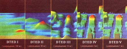
The interferometric survey mode (Interferometric SAR - IFSAR) allows you to obtain three-dimensional images of the earth's surface. At the same time, modern systems have the ability to conduct single-point shooting (that is, use one antenna) to obtain three-dimensional images. To characterize image data, in addition to the usual resolution, an additional parameter is introduced, called height accuracy, or height resolution. Depending on the value of this parameter, several standard gradations of three-dimensional images (DTED - Digital Terrain Elevation Data) are determined:
DTEDO........................900 m
DTED1.........................90m
DTED2........................ 30m
DTED3.........................10m
DTED4........................ Zm
DTED5........................1m
The type of images of an urbanized area (model), corresponding to different levels of detail, is presented in Fig. 3.
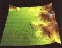
Levels 3-5 received the official name of “high resolution data” (HRTe-High Resolution Terrain Elevation data). The location of ground objects in images of levels 0-2 is determined in the WGS 84 coordinate system, the height is measured relative to the zero mark. The coordinate system for high-resolution images is currently not standardized and is under discussion. In Fig. Figure 4 shows fragments of real areas of the earth's surface obtained as a result of stereo photography with different resolutions.
In 2000, the American Space Shuttle, as part of the SRTM (Shuttle Radar Topography Mission) project, the goal of which was to obtain large-scale cartographic information, carried out interferometric surveys of the equatorial part of the Earth in the band from 60° N. w. to 56° south sh., resulting in a three-dimensional model of the earth's surface in DTED2 format. Is the NGA HRTe project being developed in the USA to obtain detailed 3D data? within which images of levels 3-5 will be available.
In addition to radar surveying of open areas of the earth's surface, airborne radar has the ability to obtain images of scenes hidden from the eyes of the observer. In particular, it allows you to detect objects hidden in forests, as well as those located underground.
Penetrating radar (GPR, Ground Penetrating Radar) is a remote sensing system, the operating principle of which is based on the processing of signals reflected from deformed or different in composition areas located in a homogeneous (or relatively homogeneous) volume. The earth's surface probing system makes it possible to detect voids, cracks, and buried objects located at different depths, and to identify areas of different densities. In this case, the energy of the reflected signal strongly depends on the absorbing properties of the soil, the size and shape of the target, and the degree of heterogeneity of the boundary regions. Currently, GPR, in addition to military applications, has developed into a commercially viable technology.
Probing of the earth's surface occurs by irradiation with pulses with a frequency of 10 MHz - 1.5 GHz. The irradiating antenna can be located on the earth's surface or located on board an aircraft. Some of the radiation energy is reflected from changes in the subsurface structure of the earth, while most of it penetrates further into the depths. The reflected signal is received, processed, and the results of the processing are displayed on the display. As the antenna moves, a continuous image is generated that reflects the state of the subsurface soil layers. Since reflection actually occurs due to differences in dielectric constants of different substances (or different states of one substance), probing can detect a large number of natural and artificial defects in a homogeneous mass of subsurface layers. The depth of penetration depends on the condition of the soil at the irradiation site. The decrease in signal amplitude (absorption or scattering) largely depends on a number of soil properties, the main of which is its electrical conductivity. Thus, sandy soils are optimal for probing. Clayey and very moist soils are much less suitable for this. Probing of dry materials such as granite, limestone, and concrete shows good results.
The resolution of sensing can be improved by increasing the frequency of the emitted waves. However, an increase in frequency has a negative effect on the radiation penetration depth. Thus, signals with a frequency of 500-900 MHz can penetrate to a depth of 1-3 m and provide a resolution of up to 10 cm, and with a frequency of 80-300 MHz they penetrate to a depth of 9-25 m, but the resolution is about 1.5 m.
The main military purpose of subsurface sensing radar is to detect mines. At the same time, a radar installed on board an aircraft, such as a helicopter, allows you to directly open maps of minefields. In Fig. Figure 5 shows images obtained using a radar installed on board a helicopter, reflecting the location of anti-personnel mines.
An airborne radar designed to detect and track objects hidden in forests (FO-PEN - FOliage PENetrating) allows you to detect small objects (moving and stationary) hidden by tree crowns. Shooting objects hidden in forests is carried out similarly to regular shooting in two modes: overview and detailed. On average, in survey mode, the acquisition bandwidth is 2 km, which makes it possible to obtain output images of areas of the earth's surface 2x7 km; in detailed mode, surveying is carried out in 3x3 km sections. The shooting resolution depends on the frequency and varies from 10 m at a frequency of 20-50 MHz to 1 m at a frequency of 200-500 MHz.
Modern methods of image analysis make it possible to detect and subsequently identify objects in the resulting radar image with a fairly high probability. In this case, detection is possible in images with both high (less than 1 m) and low (up to 10 m) resolution, while recognition requires images with a sufficiently high (about 0.5 m) resolution. And even in this case, we can talk for the most part only about recognition by indirect signs, since the geometric shape of the object is very distorted due to the presence of a signal reflected from the foliage, as well as due to the appearance of signals with a frequency shift due to the Doppler effect that occurs in as a result of leaves swaying in the wind.
In Fig. 6 shows images (optical and radar) of the same area. Objects (a column of cars), invisible on an optical image, are clearly visible on a radar image, however, it is impossible to identify these objects, abstracting from external signs (movement on the road, distance between cars, etc.), since at this resolution information about The geometric structure of the object is completely absent.
The detail of the resulting radar images made it possible to put into practice a number of other features, which, in turn, made it possible to solve a number of important practical problems. One of these tasks includes tracking changes that have occurred on a certain area of the earth's surface over a certain period of time - coherent detection. The length of the period is usually determined by the frequency of patrols in a given area. Tracking of changes is carried out based on the analysis of coordinate-wise combined images of a given area, obtained sequentially one after another. In this case, two levels of analysis detail are possible.

|

|
| Fig 5. Maps of minefields in three-dimensional representation when shooting in different polarizations: model (right), example of an image of a real area of the earth's surface with a complex subsurface environment (left), obtained using a radar installed on board a helicopter | |

|
|
| Rice. 6. Optical (above) and radar (below) images of an area with a convoy of cars moving along a forest road | |

|
|
The first level involves the detection of significant changes and is based on the analysis of amplitude readings of the image, which carry basic visual information. Most often, this group includes changes that a person can see by simultaneously viewing two generated radar images. The second level is based on the analysis of phase readings and allows you to detect changes invisible to the human eye. These include the appearance of traces (of a car or a person) on the road, changes in the state of windows, doors (“open - closed”), etc.
Another interesting SAR capability, also announced by Sandia, is radar video. In this mode, the discrete formation of the antenna aperture from section to section, characteristic of the continuous survey mode, is replaced by parallel multi-channel formation. That is, at each moment of time, not one, but several (the number depends on the tasks being solved) apertures are synthesized. A kind of analogue to the number of apertures formed is the frame rate in regular video shooting. This feature allows you to implement the selection of moving targets based on the analysis of received radar images, applying the principles of coherent detection, which is inherently an alternative to standard radars that select moving targets based on the analysis of Doppler frequencies in the received signal. The effectiveness of implementing such moving target selectors is highly questionable due to significant hardware and software costs, so such modes will most likely remain nothing more than an elegant way to solve the selection problem, despite the emerging opportunities to select targets moving at very low speeds (less than 3 km/ h, which is not available to Doppler SDC). Direct video recording in the radar range is also not currently used, again due to high performance requirements, so there are no operating models of military equipment that implement this mode in practice.
A logical continuation of improving the technology of surveying the earth's surface in the radar range is the development of subsystems for analyzing the received information. In particular, the development of systems for automatic analysis of radar images that make it possible to detect, isolate and recognize ground objects within the survey area is becoming important. The difficulty of creating such systems is associated with the coherent nature of radar images, the phenomena of interference and diffraction in which lead to the appearance of artifacts - artificial glare, similar to those that appear when irradiating a target with a large effective scattering surface. In addition, the quality of the radar image is somewhat lower than the quality of a similar (in terms of resolution) optical image. All this leads to the fact that effective implementations of algorithms for recognizing objects in radar images do not currently exist, but the amount of work carried out in this area, certain successes achieved recently, suggest that in the near future it will be possible to talk about intelligent unmanned reconnaissance vehicles that have the ability to assess the ground situation based on the results of analyzing information received by their own on-board radar reconnaissance equipment.
Another direction of development is integration, that is, coordinated integration with subsequent joint processing of information from several sources. These can be radars that survey in various modes, or radars and other reconnaissance means (optical, IR, multispectral, etc.).
Thus, modern radars with synthetic antenna aperture make it possible to solve a wide range of problems associated with conducting radar surveys of the earth’s surface, regardless of the time of day and weather conditions, which makes them an important means of obtaining information about the state of the earth’s surface and the objects located on it.
Foreign Military Review No. 2 2009 P.52-56
Modern warfare is fast and fleeting. Often the winner in a combat clash is the one who is the first to detect a potential threat and respond adequately to it. For more than seventy years, a radar method based on the emission of radio waves and recording their reflections from various objects has been used to search for the enemy on land, sea and in the air. Devices that send and receive such signals are called radar stations (RLS) or radars.
The term “radar” is an English abbreviation (radio detection and ranging), which was put into circulation in 1941, but has long since become an independent word and has entered most languages of the world.
The invention of radar is, of course, a landmark event. It is difficult to imagine the modern world without radar stations. They are used in aviation, in maritime transportation; with the help of radar, the weather is predicted, violators of traffic rules are identified, and the earth's surface is scanned. Radar systems (RLC) have found their application in the space industry and in navigation systems.
However, radars have found their most widespread use in military affairs. It should be said that this technology was originally created for military needs and reached the stage of practical implementation just before the outbreak of World War II. All the largest countries participating in this conflict actively (and not without results) used radar stations for reconnaissance and detection of enemy ships and aircraft. It can be confidently stated that the use of radars decided the outcome of several landmark battles both in Europe and in the Pacific theater of operations.
Today, radars are used to solve an extremely wide range of military tasks, from tracking the launch of intercontinental ballistic missiles to artillery reconnaissance. Each plane, helicopter, and warship has its own radar complex. Radars are the backbone of the air defense system. The latest phased array radar system will be installed on the promising Russian Armata tank. In general, the variety of modern radars is amazing. These are completely different devices that differ in size, characteristics and purpose.
We can say with confidence that today Russia is one of the recognized world leaders in the development and production of radars. However, before talking about trends in the development of radar systems, a few words should be said about the principles of operation of radars, as well as about the history of radar systems.
How does radar work?
Location is the method (or process) of determining the location of something. Accordingly, radar is a method of detecting an object or object in space using radio waves that are emitted and received by a device called a radar or radar.
The physical principle of operation of a primary or passive radar is quite simple: it transmits radio waves into space, which are reflected from surrounding objects and return to it in the form of reflected signals. By analyzing them, the radar is able to detect an object at a certain point in space, as well as show its main characteristics: speed, altitude, size. Any radar is a complex radio device consisting of many components.
Any radar consists of three main elements: a signal transmitter, an antenna and a receiver. All radar stations can be divided into two large groups:
- pulse;
- continuous action.
The pulse radar transmitter emits electromagnetic waves for a short period of time (fractions of a second), the next signal is sent only after the first pulse returns back to the receiver. Pulse repetition rate is one of the most important characteristics of a radar. Low frequency radars send out several hundred pulses per minute.
The pulse radar antenna works both for reception and transmission. After the signal is emitted, the transmitter turns off for a while and the receiver turns on. After taking it, the reverse process occurs.
Pulse radars have both disadvantages and advantages. They can determine the range of several targets at once; such a radar can easily make do with one antenna; the indicators of such devices are simple. However, the signal emitted by such a radar must have quite high power. You can also add that all modern tracking radars are made using a pulse circuit.
In pulsed radar stations, magnetrons, or traveling wave tubes, are usually used as a signal source.
The radar antenna focuses and directs the electromagnetic signal, picks up the reflected pulse and transmits it to the receiver. There are radars in which the signal is received and transmitted by different antennas, and they can be located at a considerable distance from each other. The radar antenna is capable of emitting electromagnetic waves in a circle or operating in a specific sector. The radar beam can be directed in a spiral or shaped like a cone. If necessary, the radar can track a moving target by constantly pointing the antenna at it using special systems.
The functions of the receiver include processing the received information and transmitting it to the screen from which it is read by the operator.
In addition to pulsed radars, there are also continuous radars that constantly emit electromagnetic waves. Such radar stations use the Doppler effect in their work. It lies in the fact that the frequency of the electromagnetic wave reflected from an object that is approaching the signal source will be higher than from a receding object. In this case, the frequency of the emitted pulse remains unchanged. Radars of this type do not detect stationary objects; their receiver only picks up waves with a frequency higher or lower than the emitted one.
A typical Doppler radar is the radar used by traffic police to determine the speed of vehicles.
The main problem with continuous-wave radars is their inability to determine the distance to an object, but during their operation there is no interference from stationary objects between the radar and the target or behind it. In addition, Doppler radars are fairly simple devices that only need low-power signals to operate. It should also be noted that modern continuous-wave radar stations have the ability to determine the distance to an object. This is done by changing the radar frequency during operation.
One of the main problems in the operation of pulsed radars is interference that comes from stationary objects - as a rule, these are the earth's surface, mountains, and hills. When on-board pulse radars of aircraft operate, all objects located below are “obscured” by the signal reflected from the earth’s surface. If we talk about ground-based or ship-based radar systems, then for them this problem manifests itself in detecting targets flying at low altitudes. To eliminate such interference, the same Doppler effect is used.
In addition to primary radars, there are also so-called secondary radars, which are used in aviation to identify aircraft. Such radar systems, in addition to the transmitter, antenna and receiver, also include an aircraft transponder. When irradiated with an electromagnetic signal, the transponder provides additional information about the altitude, route, aircraft number, and nationality.
Radar stations can also be divided according to the length and frequency of the wave on which they operate. For example, to study the Earth's surface, as well as to work at significant distances, waves of 0.9-6 m (frequency 50-330 MHz) and 0.3-1 m (frequency 300-1000 MHz) are used. For air traffic control, a radar with a wavelength of 7.5-15 cm is used, and over-the-horizon radars of missile launch detection stations operate at waves with a length of 10 to 100 meters.
History of radar
The idea of radar arose almost immediately after the discovery of radio waves. In 1905, Christian Hülsmeyer, an employee of the German company Siemens, created a device that could detect large metal objects using radio waves. The inventor proposed installing it on ships so that they could avoid collisions in poor visibility conditions. However, ship companies were not interested in the new device.
Experiments with radar were also carried out in Russia. Back in the late 19th century, Russian scientist Popov discovered that metal objects interfere with the propagation of radio waves.
In the early 20s, American engineers Albert Taylor and Leo Young managed to detect a passing ship using radio waves. However, the state of the radio engineering industry at that time was such that it was difficult to create industrial samples of radar stations.
The first radar stations that could be used to solve practical problems appeared in England around the mid-30s. These devices were very large and could only be installed on land or on the deck of large ships. It was only in 1937 that a prototype of a miniature radar was created that could be installed on an aircraft. By the beginning of World War II, the British had a deployed chain of radar stations called Chain Home.
We were engaged in a new promising direction in Germany. And, I must say, not without success. Already in 1935, a working radar with a cathode-ray display was demonstrated to the Commander-in-Chief of the German Navy, Raeder. Later, serial models of radars were created on its basis: Seetakt for the naval forces and Freya for air defense. In 1940, the Würzburg radar fire control system began to arrive in the German army.
However, despite the obvious achievements of German scientists and engineers in the field of radar, the German army began to use radars later than the British. Hitler and the top of the Reich considered radars to be exclusively defensive weapons that were not particularly needed by the victorious German army. It is for this reason that by the beginning of the Battle of Britain the Germans had deployed only eight Freya radar stations, although their characteristics were at least as good as their English counterparts. In general, we can say that it was the successful use of radar that largely determined the outcome of the Battle of Britain and the subsequent confrontation between the Luftwaffe and the Allied Air Force in the skies of Europe.
Later, the Germans, based on the Würzburg system, created an air defense line, which was called the “Kammhuber Line”. Using special forces units, the Allies were able to unravel the secrets of the German radars, which made it possible to effectively jam them.
Despite the fact that the British entered the “radar” race later than the Americans and Germans, they managed to overtake them at the finish line and approach the beginning of World War II with the most advanced aircraft radar detection system.
Already in September 1935, the British began building a network of radar stations, which before the war already included twenty radar stations. It completely blocked the approach to the British Isles from the European coast. In the summer of 1940, British engineers created a resonant magnetron, which later became the basis for airborne radar stations installed on American and British aircraft.
Work in the field of military radar was also carried out in the Soviet Union. The first successful experiments in detecting aircraft using radar stations in the USSR were carried out back in the mid-30s. In 1939, the first radar RUS-1 was adopted by the Red Army, and in 1940 - RUS-2. Both of these stations were put into mass production.
The Second World War clearly demonstrated the high efficiency of using radar stations. Therefore, after its completion, the development of new radars became one of the priority areas for the development of military equipment. Over time, all military aircraft and ships without exception received airborne radars, and radars became the basis for air defense systems.
During the Cold War, the United States and the USSR acquired new destructive weapons - intercontinental ballistic missiles. Detection of the launch of these missiles became a matter of life and death. Soviet scientist Nikolai Kabanov proposed the idea of using short radio waves to detect enemy aircraft at long distances (up to 3 thousand km). It was quite simple: Kabanov found out that radio waves 10-100 meters long are capable of being reflected from the ionosphere, and irradiating targets on the surface of the earth, returning the same way to the radar.
Later, based on this idea, radars for over-the-horizon detection of ballistic missile launches were developed. An example of such radars is Daryal, a radar station that for several decades was the basis of the Soviet missile launch warning system.
Currently, one of the most promising areas for the development of radar technology is the creation of phased array radars (PAR). Such radars have not one, but hundreds of radio wave emitters, the operation of which is controlled by a powerful computer. Radio waves emitted by different sources in a phased array can enhance each other if they are in phase, or, conversely, weaken each other.
The phased array radar signal can be given any desired shape, it can be moved in space without changing the position of the antenna itself, and it can work with different radiation frequencies. A phased array radar is much more reliable and sensitive than a radar with a conventional antenna. However, such radars also have disadvantages: a big problem is the cooling of phased array radars; in addition, they are difficult to manufacture and expensive.
New phased array radars are being installed on fifth-generation fighters. This technology is used in the American missile attack early warning system. The radar system with phased array will be installed on the newest Russian Armata tank. It should be noted that Russia is one of the world leaders in the development of phased array radars.
If you have any questions, leave them in the comments below the article. We or our visitors will be happy to answer them
